China is the latest to throw its sailor hat into the ring, but it won't likely be the last in this long-running, hotly contested debate.
The Chinese voyage to America theory was popularized by British amateur historian Gavin Menzies in his 2002 book entitled '1421: the Year China Discovered America.' The controversial, bestselling work claims that Chinese admiral Zheng He reached the Americas more than 70 years prior to Christopher Columbus' famous voyage.
After reading '1421,' Liu Gang, a Chinese lawyer, realized the potential significance of a map he'd purchased for his private collection. Dated 1418 and clearly depicting the outlines of both North and South America, the map could be used to support Menzies' theory if it proves legitimate.
Forgery?
Liu unveiled his map at a packed press conference in Beijing on Jan. 16.
Despite arousing immediate international interest, the map was quickly dismissed by many historians as an outright forgery.
'Scholars who know this field have refuted this claim under no uncertain terms,' Sally K. Church, Fellow at the University of Cambridge, told LiveScience.
Geoff Wade, Senior Research Fellow at the University of Singapore's Asia Research Institute, echoed her sentiment. 'The map is an 18th-century copy of a European map, as evidenced by the two hemispheres depicted, the continents shown and the non-maritime detailed [sic] depicted,' he wrote recently to a group of maritime scholars.
In the other camp, Menzies is supporting Liu and the 1418 map with fervor. His key reasoning, forwarded by email from a member of his staff, is that "every continent, ocean, land, island, river shown on the 1418 map also appears on other Chinese maps of the same date or earlier. There is nothing new on the 1418 map—it simply combines everything on one sheet of paper," he said.
Menzies also points to a Portuguese map of the Americas dating from 1419 whose mistakes—like the drawing of California as an island—are thought to have been copied from cartographic errors made by the Chinese.
"In 1419 European voyages of exploration had not started. If the 1418 map is a forgery, then the 1419 map must be as well. How do you forge something yet to be discovered," Menzies reasoned.
British magazine The Economist recently printed an article about Liu's prized possession, quoting both supporters and detractors of Menzies' beliefs.
In a letter written to The Economist and provided to LiveScience, Wade, the critic of the map from the Asia Research Institute, urged its editor to print a retraction.
"That your writer has contributed to the Menzies' bandwagon and continuing deception of the public is saddening," Wade wrote. "The support mentioned all comes from Mr. Menzies' band of acolytes and the claims have no academic support whatsoever. Your writer has been taken in by Mr. Menzies and you do have a social responsibility to rectify this."


The “Liu/Menzies” World Map: A Critique
ReplyDeleteGeoff Wade
Asia Research Institute
National University of Singapore
1. Introduction
It was in late 2005 that Mr. Gavin Menzies, author of the infamous 1421: the Year China Discovered the World (or 1421: the Year China Discovered America in the U.S. version) began hinting that “further evidence” in support of his thesis had become available through a map, newly-discovered in China. In his interview with the Shenzhen Economic Daily of 19 November 2006, he showed the interviewing journalist a copy of a Chinese map of the world which he claimed had been drawn in 1418. He noted that the map was the first to show Australia and New Zealand, and that a European map which was drawn in 1419 was a copy of this Chinese map. He also advised that the map was undergoing isotopic (C14) dating.
Those who had had experience with Mr Menzies’ modus operandi and his repeated dubious claims were not terribly excited. All Mr. Menzies’ claims of great discoveries had, in the end, invariably shown themselves to be damp squibs with neither the nature nor the potential to fulfil the promises of new discoveries. This new map was to prove no exception.
On 12 January 2006, all was revealed. The Economist magazine of that date carried in both its print and online editions, an article on the promised map along with an image. The accompanying article, penned by one Stephen Fay, read like a media release by Mr. Menzies’ publicists, including statements such as: “It seems more likely that the world and all its continents were discovered by a Chinese admiral named Zheng He, whose fleets roamed the oceans between 1405 and 1435.” Most disingenuous is the conclusion reached in the final paragraph, which baldly claims: “It is no less interesting that the Chinese, having discovered the extent of the world, did not exploit it, politically or commercially.”
Why should anyone choose to publicize a map through a news magazine, prior to any scientific study or attestation of veracity? It was obviously to maximize exposure. And that is what this whole process has been about — maximizing publicity and exposure so that Mr. Menzies can attract more attention for his 1421 volumes and Mr. Liu Gang, the owner of the map, can gain his few minutes of fame and advertise his map to potential buyers. It is the typical circus which has accompanied all Mr. Menzies’ claims since 2002, even prior to the publication of his book.
Why has this conclusion been reached? Firstly because, as a student of Ming China’s foreign relations, I have been a close observer of the 1421 phenomenon since it began, and have followed the repeated instances of Mr. Menzies trying to drum up excitement for his cause through fabricated evidence. Secondly, the map comprises a litany of errors which show clearly that the map is a complete fake, likely produced within the last decade.
The Economist article was the opening salvo for a number of publicity events. Liu Gang “launched” the map in Beijing on 16 January 2006, while Menzies presented it to the Friends of the National Maritime Museum (a private body) in Greenwich on 17 January 2006. Amazing claims about how the history of world discovery would have to be rewritten were followed by statements such as “every continent, ocean, island and river shown on the 1418 map, acts as corroborative evidence that Zheng He’s fleets had visited those sites.” The speciousness and brazen nature of the claims left many in the cartographic history world speechless, but the claims were quickly relayed around the world by gullible and uncritical media organisations.
Chinese scholars were quick to respond, and in February and March, Jin Guo-ping, Hou Yang-fang, Zhou Zhen-he and Gong Ying-yan penned individual pieces which picked gaping holes in the historicity of the map. Several of these critiques are available in English-language translation.
Attempts to salvage some veracity for the map were then made by Mr. Menzies himself, who averred that this map is “absolutely, completely authentic,” further noting “There are several reasons why. There are a number of European maps based on this one, and they would also be forgeries if this were a fake. There is a mass of corroborative evidence, and everything in the map appears in separate Chinese records. Finally, European explorers found Chinese junks and evidence of Chinese people in North America. This shows the Chinese were there first.” Every sentence of this statement is specious. As will be shown below, the map is not authentic. Ergo, there are no European maps based upon it, and there can be no corroborative evidence. In addition, the features on the map cannot be found in any earlier Chinese map, and no early European explorers found attested evidence of Chinese junks or Chinese people in the Americas.
Further efforts to bring some respectability to the map were made by Mr. Liu Gang and Dr Gunnar Thompson, the latter declaring himself to be serving his second year “as cartographic consultant to British author Gavin Menzies and the 1421 Team.” By March 2006, the results of the C14 dating had been obtained and a press conference was held by Messrs Menzies, Liu and Thompson at a Beijing book shop. To nobody’s surprise, the carbon date, obtained from a Waikato University laboratory, was shown to indicate that the sample of paper submitted to it very likely came from the 18th century. However, there was no proof at all that the sample submitted came from the map, as the place where the piece was allegedly taken from has never been illustrated and the tested piece had no ink or any other markings on it.. Challenges issued on the online Map History Discussion Group (http://www.maphist.nl/) in May 2006 by Mr. Michael Ross, President of the Australian Map Circle, to Mr. Liu Gang, seeking some evidence proving that the sample came from the map, have been met with a stony silence from Mr. Liu. We thus really have no attested evidence as to the real date of the map or the paper it is drawn on.
In their attempts to prove themselves legitimate members of the scholarly community, Mr. Liu and Dr Thompson also began frequent communications to the MapHist list in April and May, putting forward claims about the map and its veracity. Gunnar Thompson also claimed that the dual hemisphere map format was actually a Chinese rather than a European innovation, deriving from Taoist iconography. This map, he claimed, was thus the basis by which this dual-hemisphere format passed to European cartographers!! These two gentlemen left the list as quickly as they appeared when it became apparent that the many map historians and others specialists on the list required some basic evidence for the claims being made.
Most recently, Mr. Menzies travelled to Australia and New Zealand in April/May 2006, and regaled the Antipodeans with claims that their cartography began with Zheng He’s fleets in the 1420s, and that this cartography proves that the Chinese navigators had a means for calculating latitude and longitude. The nonsense being purveyed is somewhat dangerous and, while the map is but one component of the Menzies’ global hoax, it needs to be shown for what it is—a fabrication intended to deceive.
2. The Liu/Menzies Map
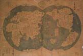
The map in question, variously called by its supporters the “1418 map”, the “1418/1763 map” or the “Zheng He map”, will be here referred to as the “Liu/Menzies” map, given that it has no proven connection with 1418, 1763 or Zheng He, and given that its prime publicists are Mr. Liu and Mr. Menzies. As noted above, the first opportunity that the world had to view this map came with an illustration in The Economist in January 2006. More recently, a high resolution version has become available.
The first thing that impresses is the fact that this is a dual hemisphere map. At the top right of the map are the characters Tian-xia quan-yu zong-tu (天下全輿總圖), which can be approximately translated as “Overall Map of the Complete Geography of all Under Heaven”.
(Illustration 1 here)
In the bottom left-hand corner of the map, we find characters which translate as: “Copied by Imperial subject Mo Yi-tong in the second month of spring in the kui-wei year of the Qian-long reign [1763] from a map of tributary barbarians from all under Heaven of the 16th year of Yong-le reign of the Ming dynasty [1418]”
(Illustration 2 here)
In the top left-hand corner of the map, there are characters which translate as: “Those annotations without red borders are not from the original map”. Liu Gang explains it thus: This means that there were some annotations which were on the original “Map of tributary barbarians from all under Heaven” and some were added later by the copier. The original annotations are enclosed on this map within red borders. In other words, all those annotations within red borders were from the original map.
(Illustration 3 here)
In a square box located in the sea just south-west of the modern California, there is contained a text which can be translated as follows: “In the 13th year of the Yong-le reign (1415), I followed the senior envoy, the eunuch director Ma San-bao, and others to Bengal and other barbarian lands all the way to Hormuz and such countries, to read the royal proclamations and confer rewards. In the 16th year (1418), I returned to the capital.”
(Illustration 4 here)
Here then are the key elements suggested by the Liu/Menzies map. A person who supposedly accompanied the eunuch envoy Zheng He (the Ma San-bao mentioned above) “all the way to Hormuz” during a voyage over the years equivalent to 1415-1418 C.E. is claimed to have drawn a map which served as the basis for the “1763 map” we are examining. The place names and descriptions which were allegedly copied from the “15th-century map” are circled in red to indicate that they were from the original map. The other toponyms and descriptions are by implication from 1763, the date this map is said to have been drawn by the alleged map-maker Mo Yi-tong.
3. The Critique
This map was purportedly derived from a map produced by an individual who accompanied Zheng He from China to Hormuz and back to China. The voyages of Zheng He and his commanders from 1406 to the 1430s are well-known and have attracted much attention. The 15th-century texts available to us which directly bear on these voyages include the various references to Zheng He within the Ming shi-lu (or Veritable Records of the Ming Dynasty). In addition, three persons who accompanied these voyages left us with fairly detailed accounts of the routes and the places visited — Ma Huan, Fei Xin and Gong Zhen. Louise Levathes’ 20th century study of the voyages — When China Ruled the Seas: The Treasure Fleet of the Dragon Throne 1405 – 1433 — is a popular yet reasonably accurate account of the voyages. All of the available documentation informs us that these fleets sailed from Eastern China to what is today called Southeast Asia, to South Asia, the Middle East and the East Coast of Africa. Ports and polities all along this route are well-described in the books mentioned above. There is no indication from any Chinese text, however, that the fleets went any further. Of course, Mr. Gavin Menzies in his fabricated work 1421: The Year China Discovered the World claims, on the basis of distorted or invented “evidence,” that commanders of these fleets circumnavigated the globe, “discovering” the Americas, Australia, New Zealand, Greenland, sailing across the Artic Circle and into the Antarctic and, in the process, mapping the world.
The correlation between Mr. Menzies’ claims and the conclusions one could draw from this map are stunning. It is thus not surprising that Mr. Menzies features the map on his website, participates in press briefings publicizing the map, and provides Mr. Liu Gang with much space on the 1421 website to declaim on why he feels the map is genuine. We could thus reasonably conclude either that Mr. Menzies’ thesis does have some basis, or that the map is a fake and likely created to support the Menzies’ thesis. I will provide evidence that the latter is the case.
4. The Evidence Against the Veracity of the Map
The evidence against the map can be divided into a number of areas. First some general statements are in order. The map is drawn in a dual-hemisphere format, a European cartographic tradition beginning in the early 16th century. Some have claimed that this map was, at least in part, copied from a 17th-century European map, as California is represented as an island. However, as China is placed at the centre of the map — as it was in early Jesuit maps of the world produced in China — it is more likely that it is a rough copy of a Jesuit-inspired Chinese map of the world, with modern additions detailed below.
However, the map’s supporters suggest that the map in fact derives from the early 15th century, predating the Jesuits arrival in China by 150 years. There are a number of factors which militate against this. The creation of such a map is conditional upon recognition that the world is a sphere. No indigenous Ming maps show that there was a Chinese belief in the 15th century that the world was a sphere. Further, for a sphere to be represented on a flat plane, there needs to be knowledge of and methods for projection. Chinese cartographers did not have this knowledge until after the arrival of the Jesuits.
The map’s owner and his fellow travellers also claim that the map was produced by voyagers who accompanied Zheng He’s ships on their journeys around the world. That is to say, they suggest that the map was produced by mariner cartographers. However, the amount of non-coastal detail (including riverine systems extending thousands of miles inland from the coast) indicate that this map could not have been produced by maritime voyagers. The information in the maps was obviously amassed over a considerable number of centuries by cultures which had travelled the world widely. It fits perfectly within the history of European cartography, but is a complete anomaly in Chinese cartography.
The map was supposedly drawn in 1763 for submission to the Court by someone called Mo Yi-tong, based partially on a “map of tributary barbarians from all under Heaven of the 16th year of Yong-le reign of the Ming dynasty [1418/19],” and with the annotations of the earlier map circled in red on the extant version. Such a mode of attribution is not a part of Chinese cartographic tradition and neither is circling of particular names in red to indicate that they derive from an earlier map. Further, the representation of China is poor. Why should Chinese cartographers have represented the lands with which they were so familiar (and which are shown in other earlier maps much more accurately) so poorly? And, tellingly, there is no historical source, Chinese or otherwise, which attests the existence of the supposed author Mo Yi-tong.
But it is the annotations which demonstrate most clearly the nature of the map as a fake. As noted, the map distinguishes between the annotations within red borders (supposedly from a 1418/19 map) and those unbordered which are implicitly from 1763. We will examine these separately.
The 1763 Annotations
Firstly, the name of the map presents problems. The map is entitled Tian-xia quan-yu zong-tu (天下全輿總圖). This makes no sense as a map name, “quan yu” (complete geography) and “zong tu” (overall map) cannot be used in the same title. In fact, the term “quan-yu” (complete geography) was never used in Chinese cartographic description. This suggests a modern faker with little knowledge of traditional Chinese cartographic description.
In describing the original map, the author uses the term “shi-gong-tu” (識貢圖) to refer to the 15th-century Ming map of tributaries. There is no such genre in classical Chinese literature. What is alluded to is the “zhi-gong-tu” (職貢圖) – “Illustrated Tributaries”– a genre of description and illustration of tributaries (but certainly not maps), extending back as far as the Liang dynasty. The graphic similarities of the two characters shi (識) and zhi (職) and their similarity of pronunciation in the Shanghai dialect clearly show how the confusion came about and again underlines the fact that the faker was a modern person unfamiliar with the institutions and literature of imperial China.
(Illustration 5 somewhere here)
Further proof of the modernity of our map creator can be gleaned from a close examination of the characters used in the annotations. In at least three cases, the cartographer uses simplified characters. The character “yu” to indicate “–plus” is repeatedly written as 余 rather than the formal 餘. While this simplified form did indeed exist as short-hand in the 18th century, it would certainly not have been used on a formal document intended for submission to the court. For a modern Chinese person, educated within the last 50 years, however, the simplified form is the standard character and it is easy to understand how our faker would not have been aware of the distinction, thereby providing us with another clue for dismissing the map.
(Illustrations 6 and 7 somewhere here)
A number of other anachronisms can also be found. On this supposedly 18th-century map, the annotation located on the Himalayas tells us that these are the highest (literally: the “Number one”) mountains in the world. The knowledge that the Himalayas contained the highest peaks in the world, however, was only gained in the 19th-century after all of the tallest peaks in the world had been measured. How was an 18th-century Chinese map-maker to have known this?
Further anachronisms of geographical knowledge have been pointed out by Liu Gang himself in his article. He notes that the map shows the Amery Ice Shelf in Antarctica, first depicted on world maps in the 1960s! Kerguelan Island is also shown, supposedly before it was even “discovered” by Kerguelan. Mr. Liu suggests that these characteristics point to the veracity of the map. I suggest that they point in precisely the opposite direction.
The Red-Bordered Annotations
The map claims that the annotations bordered in red are from the original (15th -century) map. Again, the historical inaccuracies and anachronisms of the annotations within red demonstrate that the creator of the map was a far from competent faker. Anyone with a basic competence in Ming texts will be able to identify the language of this map as not being congruent with usual Ming language, cartographic or otherwise. It is a modern attempt at sounding “classical”. But that is of course a subjective assessment. Let us proceed to some of the more objective indicators of fabrication.
To begin with, the eunuch commander Zheng He is referred to on the map as Ma San-bao, Ma being the original name of Zheng He. No-one in 1418 would have dared to use the eunuch’s original name given that the Yong-le emperor had assigned him the surname Zheng. But it is the toponyms and annotations per se which are most telling. A few examples will suffice
• In eastern Europe, there is an annotation within a red border which notes: “The people here all worship God (shang-di) and their religion is called ‘Jing’.” The term “shang-di” in reference to the Christian God was adopted by the Jesuits only in the late 16th century, and the recognition in China of Nestorianism (“Jing”) as a branch of Christianity occurred only in the early 17th century. There is no possible way that these could have appeared in this context on a 15th-century map.
(Illustration 8 somewhere here)
• In an annotation situated north of India in what is today Central Asia, the text reads: “Travelling from East to West, after leaving Jia-yu Gate, in any city where one arrives, the people will all be believers in Islam and worship Muhammad…” Two issues are immediately apparent. Muslims, of course, worship Allah and do not worship Muhammad. In no other Chinese text, Ming or otherwise, is the claim made that Muslims worship Muhammad. This would not have been written by someone who had accompanied the Muslim eunuch commander on his voyages, and is likely a product of the ignorance of the modern map-maker. In addition, the characters used to represent the name Muhammad—Mo-ha-mo-de (莫哈莫德) — are not used in any Ming text to represent the prophet Muhammad. They are, however, precisely those used by 21st-century Chinese persons to represent the Arab name Muhammad!
(illustration 9 somewhere here)
• The name of Korea is given as Gao-li. By 1418, the Chinese name of this polity had long been changed to Chao-xian.
• The name of Vietnam is given as Annam. By 1418, this had long become the Chinese province of Jiao-zhi.
• The Chinese provincial names Hu-bei and Hu-nan are given in their modern locations. In 1418, these provinces had not even been created, and the areas were part of the predecessor province of Hu-guang.
• There are a number of red-bordered annotations reading “Great Qing Ocean” in the seas off China. These purportedly date from 1418, 230 years before the Qing dynasty had been established.
• The island of Taiwan is named as “Ryukyu”. During the Ming, the country of Ryukyu was a tributary of the Ming and the Ming certainly knew where it was. There is no evidence that Taiwan was referred to as Ryukyu during the Ming.
• The map refers to the southern and northern Chinese “capital areas” by the term zhi-li, but this referent was only created with the designating of the new capital of Beijing in 1421, 3 years after the map was supposedly drawn.
In short, these anachronisms in toto entirely undercut any possibility that the red-bordered annotations are from a map drawn in 1418.
Mr. Liu seems to place great store in the aged appearance, “vermin holes,” smell and other attributes of the map to validate its age. Those familiar with the faked “ancient books” now freely available in the markets of China and Hong Kong will recognise the “insect holes” and other “ageing” techniques used on this map. The methods are identical.
In short, the map is simply a litany of errors, many simplistic. There is absolutely no possibility that it is anything but a product of the last 50 years, and quite possibly of the last five years. Not a single Chinese scholar of cartography assigns it any veracity at all. In an article carried in The Beijing News, Professor Zhou Zhen-he (周振鹤), a prominent historical geographer employed in the Chinese Geography Research Institute of Fu-dan University in Shanghai, noted of the map: “The methods used in producing this fake map are so poor and low-quality, with even descriptions in recent newspapers being sufficient to show that it is a fake ‘ancient map’.” When the senior experts in Chinese cartography are so convinced of the fraudulence of this map, Mr. Menzies and Mr. Liu are going to be hard-pressed to convince the world elsewise.